A303 ROAD SCHEME
A303 Stonehenge Road Scheme
13 Aug '24
On 29 July 2024 the new government cancelled the 1.7bn A303 Stonehenge tunnel scheme
By Carolyn MacDougall and Julian Glyn-Owen
The A303 road scheme from Amesbury to Berwick Down was given planning permission by the previous government in November 2020 but had faced a series of delays due to legal challenges by Stonehenge Alliance. The cancellation also means that the much-needed Winterbourne Stoke bypass was also scrapped.
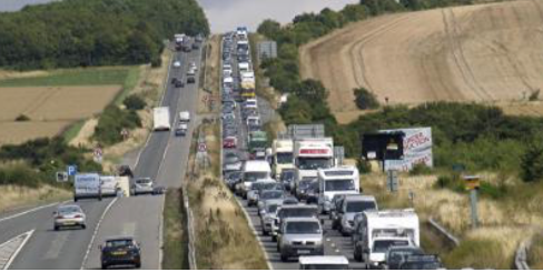
The road plan has been controversial with some local communities split on the issue. The need to alleviate massive regular traffic congestion in the area and stop rat-running through our villages is now impossible. The vision to deliver an enormous uninterrupted landscape for locals and tourists to walk far south to Wilsford and the Woodford Valley - away from traffic – is now impossible. The scheme would have reconnected the Stonehenge landscape for future generations to enjoy with the tunnel deep below any possible archaeological material due to its depth.
A brief history
The road by Stonehenge comes with a long history of solutions and cancellations. In early 19th century it was designated as the ‘new direct road’ to Exeter but through neglect this route became little more than a rough track. The A303 was created on 1 April 1933 as the ‘alternative London-Exeter route’ (instead of the A30). In 1958 the Ministry of Transport upgraded the A303 to a trunk road status and several improvements such as dualling took place in the late 1960s. In 1971 the Conservative government announced that the A303 would be improved but a planned dual carriageway past Stonehenge was abandoned. Further improvements were planned in the 1980s but again abandoned by the Thatcher government. In 1986 Stonehenge was added to the UNESCO World Heritage Site covering some 6,500 acres and to include the A303. Another plan in 1989 included a Winterbourne Stoke bypass. In 1993 the Minister for Roads announced plans for either a 0.5 km tunnel or diversion at a cost of £22m-£44m which was subsequently cancelled by Tony Blair’s government in 1998. In 2003 a 2.1km tunnel bored under land adjacent to Stonehenge was announced but by 2006 costs had doubled to £510m. In 2007 Gordon Brown’s government cancelled the whole scheme.
The latest plan
In 2016 a 2.9km Stonehenge tunnel road scheme (including a Winterbourne Stone bypass) was revived by the government. In excess of 60 road routes were assessed. In February 2017 public consultations began on just two alternative routes. Berwick St James, together with other southern Till Valley campaigners, raised private funds and commissioned a range of consultancy reports. The decision by Highways England was to propose the A303 bypass go north, between Shrewton and Winterbourne Stoke. Avoiding the SSSI and ancient wooded Carr running through the southern section of the River Till.
To date the government has spent £166 million on the now scrapped scheme; from consultants to archaeologists. If the bypass or programme is re-initiated, all this elementary survey and feasibility work must be re-done. Previous scheme data is inadmissible.
For many there was a sigh of relief that this scheme has been scrapped. For others such as numerous local communities, Wiltshire Council and English Heritage the decision to cancel was extremely disappointing. Doing nothing is never going to be an option. The weeks of work and disruption on the tunnel power supply installation on the A360 from Salisbury to the A303 is now a wasted effort.
The Southwest of England’s road transport is severely hampered by the lack of dual carriageway on sections of the A303. A major cause of delays remains the Stonehenge section, the first single carriageway road section from London. It is a bottleneck and barrier to economic development to the west. One might well question the government’s decision as being short-sighted and not looking at the longer-term economic benefits. There is no doubt that at some stage yet another road scheme will re-emerge. One can only hope that it will also be for the benefit of the local living communities.
19 Feb '24
STONEHENGE ALLIANCE LOSE HIGH COURT CHALLENGE OVER A303 STONEHENGE TUNNEL PROJECT by Carolyn MacDougall
Following the recent news regarding the proposed closure of the A360, it has been announced today that Save Stonehenge World Heritage Site (SSWHS) has lost their High Court challenge. (Click here for the full story). Mr Justice Holgate largely dismissed Stonehenge Alliance claim, finding most parts of their case were unarguable. One part of the legal challenge regarding the environmental impact will be determined at a later date.
This ruling now means that Highways England can start to proceed with their plans.
Save Stonehenge Alliance (SSWHS) 2nd Legal Challenge: A303 Stonehenge road scheme by Carolyn MacDougall
Following the latest legal challenge, I will clarify where we are with regards to the A303 Stonehenge scheme.
[In August 2021 the Judge found the decision to grant DCO (Development Consent Order) to be unlawful on 2 out of 10 grounds and the DCO was quashed. The DfT (Department for Transport) did not appeal but applied for re-determination. Full details can be found on our website.]
July 2023
* The Transport Secretary granted DCO to start work on the scheme (second time).
* SSWHS announces a legal challenge.
12 December 2023
* A three-day Roll Up Hearing was held at the Royal Court of Justice where the parties involved presented their arguments to the Judge. As I understand it, unlike the previous course of action in 2021, the Judge will make a decision without having to return to the High Court for a further hearing.
Thereafter
* Based on the above hearing, it is expected that the Judge will make a decision in February/March 2024 as to wether this DCO was lawful or not.
* Highways England and the DfT remain confident that the scheme delivers the best solution.
* In the meantime no construction work can commence on the road scheme.
--------------------------------------------------------------------------------------------------------------------------------------------
FRIDAY 14 JULY 2020
A303 STONEHENGE ROAD SCHEME APPROVED BY TRANSPORT SECRETARY
The Transport Secretary, Mark Harper, today granted a DCO (Development Consent Order) for the Amesbury to Berwick Down road scheme to go ahead.
A re-cap:
12 November 2020 the then Secretary of State, Grant Shapps, granted DCO to start work on the road scheme.
30 July 2021 the Courts quashed that decision as ‘unlawful’ on two grounds out of ten. [refer to previous Updates]
30 November 2021 the Secretary of State announced the ‘Statement of Matters’ where he set out points requiring further information following the Judicial Review.
Since then robust and comprehensive consultations have taken place to reassess the Development Consent Order.
In reaching his decision, the Secretary of State has considered the need case and other benefits and impacts, including harm to the World Heritage Site and the Outstanding Universal Value as well as potential route alternatives. The harm to heritage assets are outweighed by the benefits of the Proposed Development.
There now follows a six-week period in which to ascertain if any new Judicial Review claims are lodged.
For full information, click here to go to the letter from the Department for Transport
In January 2017, Highways England held a public consultation on options to upgrade the A303 between Amesbury and Berwick Down.
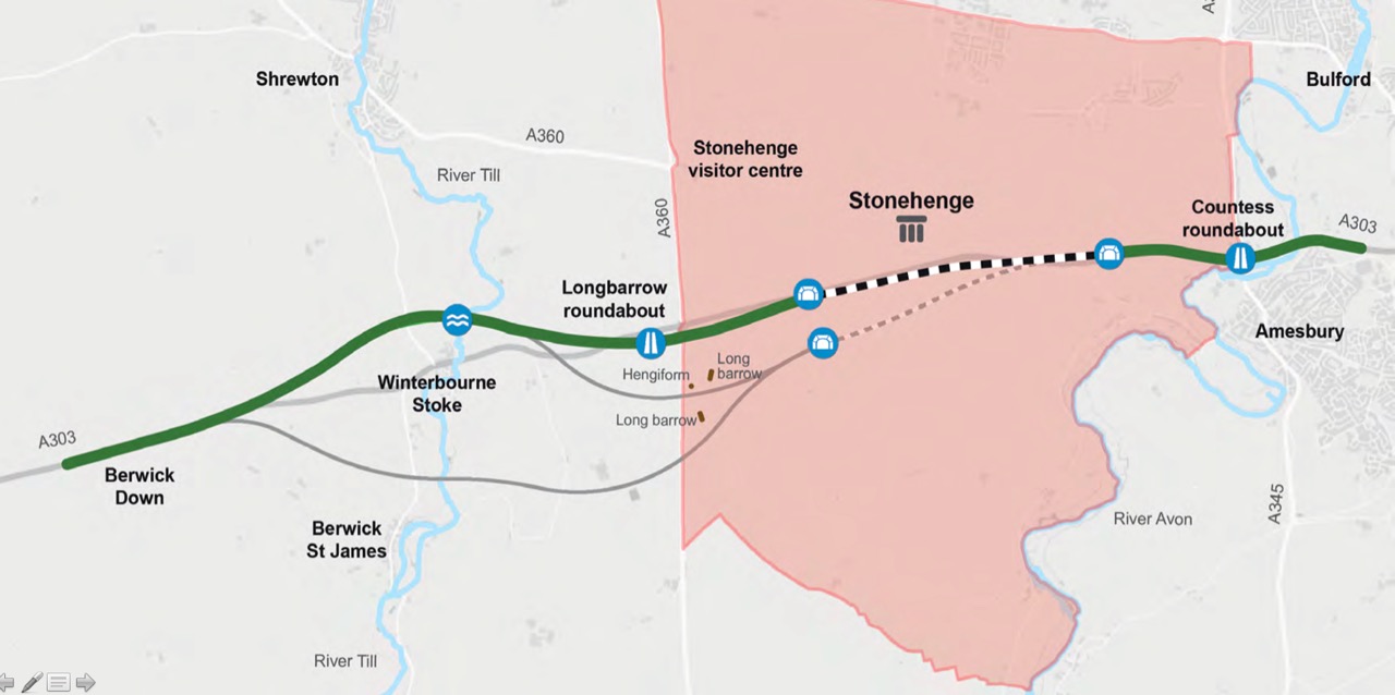
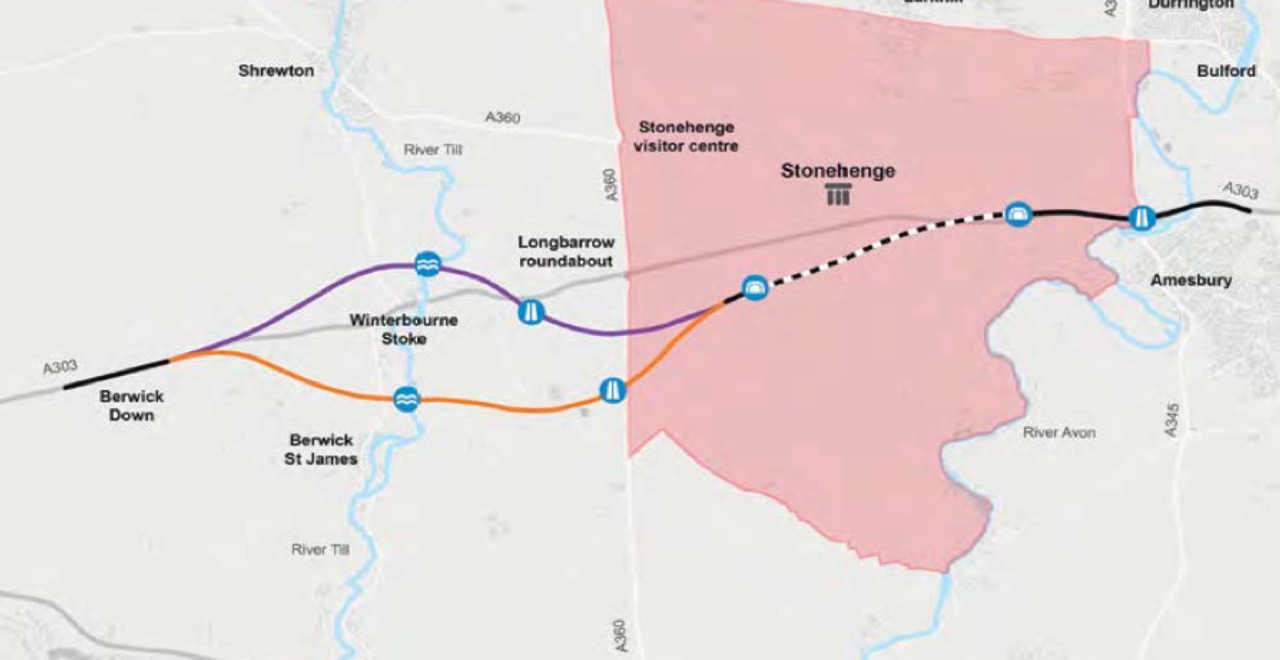
Their proposed option was to propose that a tunnel route through the World Heritage Site (WHS) together with a bypass of Winterbourne Stoke either to the north or south of the village would be the best solution for the scheme.
- A new junction between the A303 and A345 at the existing Countess roundabout.
- A 1.8 miles (2.9 km) long twin bore tunnel by Stonehenge.
- A new junction to the west and outside the WHS for traffic on A303/A360 as well as a link to Winterbourne Stoke.
- Two bypass options (north and south) for Winterbourne Stoke.
A series of public consultations took place where information on the scheme was made available. Highways England asked the public to complete their consultation questionnaire by 5th March 2017.
Timeline:
2017 Public Consultation on proposed options (January/February 2017)
Preferred route announcement (summer…autumn 2017)
Pre-Development Consent Order (DCO) application consultation (late 2017)
2018 Submit DCO Application (mid 2018)
2019 DCO examination (late 2018 to mid 2019)
Recommendation and Decision by Secretary of State for Transport (late 2019)
2020 Start on site (early 2020)
Berwick St James Campaign - CPSTV
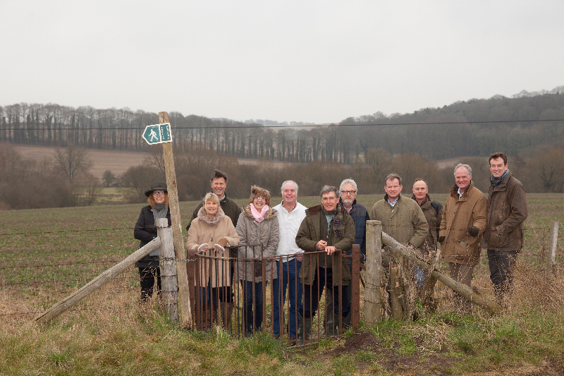
In February 2017, a focussed group of residents from the southern Till Valley volunteered to work together for the preservation of our tranquil community. The name chosen was Campaign for the Preservation of the Southern Till Valley (CPTV). The aim of the group was to ensure that everything that can be done would be done to protect the valley (between Berwick St James and Winterbourne Stoke), which would be hugely affected if the southern bypass were to be chosen.
Key areas of approach:
- Challenge Highways England on the lack of data provided.
- Commission professional consultancy companies to provide irrefutable scientific and ecological data.
- Raise funds to finance the reports needed.
- Planning and executing a co-ordinated media campaign.
- Encouraging residents to complete questionnaires.
- Liaising with other local communities and concerned groups.
- Addressing our issues with local and central government bodies.
[For full details about our campaign, refer to ‘Community Matters’ bulletins and Press Releases]
Government Announcement on preferred route
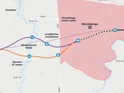
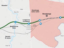
On Tuesday 12 September, the Government announced the route for the £1.6 billion A303 upgrade near Stonehenge. It followed feedback from thousands of individuals and organisations as well as engagement with local communities, heritage groups, archaeologists, historians and engineers. Highways England has modified the plans, including moving the position of the western tunnel portal to avoid conflicting with the solstice alignment.
The preferred route includes:
- 8 miles of free-flowing, high-quality dual carriageway
- A tunnel at least 1.8 miles long underneath the WHS and closely following the line of the existing A303 avoiding important archaeological sites.
- A new bypass to the north of Winterbourne Stoke.
- A360 junction moved further north and west.
For full information visit: www.highways.gov.uk/a303stonehengepra
The Campaign for the Preservation of the Southern Till Valley response
The group, together with residents in the southern Till valley are pleased that a decision has finally been made and relieved that a northern bypass of Winterbourne Stoke has been chosen. No road scheme was ever going to be perfect, but we believe that what is on the table represents the most logical option. It was always going to be a complex scheme in an area of great historic value and outstanding natural beauty.
Our job is far from over. Once full details of the route are made public, our next step will be to look at areas where further mitigation might be appropriate particularly with regard to the northern route. For example, review hydrology concerns arising from the Till viaduct crossing which could impact the southern Till valley; ensure good access to Shrewton and the A303/A360 junction and; maximise landscaping.
--------------------------------------
Comments by Local Residents for Questionnaire
Location: Berwick St. James - Posted February 4, 2017 10:02 am
Charles Street
This is some of my response to Highways-England. If you wish to pick out bits to use, please do so. However, do not copy it word for word; I have put this here for ideas only.
BEST ROUTE
NOISE & VISUAL IMPACT.
The southern route will have a noise impact on a large number of people.
I live at the southern end of Berwick and can hear the traffic on the A303 when in my garden now; I fear that it will be a lot worse with the southern route in place.
It will have a huge noise & visual impact on all the residents of Berwick & Asserton.
The residents of Winterbourne Stoke, most of whom live south of the existing A303, will also suffer from noise, due to the prevailing southwest winds.
It will also have a massive visual impact on them, as they will be looking straight into it.
All the above also applies to those who live around the camp sight between the two villages as it goes very close to them.
The noise & visual impact will only get worse as the amount of traffic will increase over time.
The northern route will have much less of a noise and visual impact on far fewer people.
SAFETY.
There is a grass runway situated to the north of Yarnbury Castle, which is almost in line with the line of the southern route as it comes up in a North Westerly direction from the B3083 to meet the existing A303 at the eastern end of the Wylye bypass (it can be seen on Google maps in Earth view). The runway is used by the MOD for Hercules short take-off and landing exercises during the day & at night. The headlights of the vehicles could temporally blind the pilots or the landing lights of the aircraft could temporally blind the vehicle drivers or both. Whichever way you look at it, there is a very nasty accident waiting to happen.
SOCIAL/FINANCIAL
The southern route will act as a barrier between the two villages, which currently is not there. It will cut the two villages off from each other, both of which currently enjoy cultural & social interaction with each other.
The benefice magazine is called ‘The Lower Wylye & Till Valley Benefice Magazine and is not distributed in Shrewton. It is distributed to W-S, Berwick etc, W-S being the northern most village. Therefore showing W-S looks south towards Berwick rather than north towards Shrewton.
The small community between the two villages (known locally as ‘Over the Hill’) feel connected & closer to Berwick rather than Winterbourne Stoke & the southern route would completely cut them off from Berwick.
The campsite at ‘Over the Hill’ brings a lot of much needed trade to Berwick (the pub & shop) during the tourist season; I feel that this much-needed source of income will dry up if the southern route was put in place.
There are also many public rights of way forming circuits that are used by local walkers and horse riders from both communities. The southern route would interrupt these rights of way, whereas the northern route only seems to cut through two rights of way.
The Druids Lodge estate will have one of their sources of income very badly affected by the southern route. It is a very well known estate for game shooting, particularly for Partridge, having many people from overseas & the UK to shoot game. If the southern route is chosen, it will cut the estate in half and ruin one of the best Game shoots in this country, which will have a financial nock on effect on other local businesses.
ENVIRONMENTAL/POLLUTION
The airborne pollution from vehicles on the southern route will blow straight into W-S and ‘Over the Hill’ on the prevailing SW winds. Those people with breathing problems will suffer a lot more than they do now.
What about babies? It is not good to have them breathing in vehicle pollutants all the time and could then cause a lifetime of breathing difficulties.
The airborne pollution will only get worse as the amount of traffic increases over time.
The water meadows between the two villages have a large number of springs in them, which supply the River Till with water all year round, so from W-S downstream the Till flows all year, apart from very dry years. Whereas upstream of W-S the Till is a true winterbourne (which does not flow every year, depending on rainfall). Because of this there is a lot more water related wild life downstream of W-S than upstream. Some of this wild life is classified as rare including ‘‘Desmoulins’ whorl snail’’ & The Bullhead, amongst others.
The construction of the southern route Viaduct, and associated works, over the Till SSSI/SAC (vehicle movements, pile driving, earthworks etc.) will have a detrimental effect on all the water related wild life, which could continue for a long time into the future.
There is also the risk of polluting the river, during construction, which is well known for its cleanliness and purity of water.
The construction of the northern route Viaduct will have much less of an effect on water related wild life as there is not going to be very much if any at all.
If the northern Viaduct is constructed when the river is not flowing or dry, then any pollution risk is minimised as it can be cleared up before it is washed downstream and damages the delicate eco-system of the river.
On the southern route there will be quite a few mature trees cut down just to accommodate the road, never mind the extra ones for the junction on the A360 & probably others to make the work easier, and access for work vehicles etc. This will have a devastating effect on the wild life in the Lower Till Valley, Barn Owls, Bats, Red Kites, amongst many others.
On the northern route far fewer trees will need to be destroyed, therefore the effect on the wild life living in, on, under and around these trees will be far less on the northern route than the southern route.
The concrete foundations of the Viaduct on the southern route will affect the springs in the water meadows, which could be detrimental to the water flow from those springs with unforeseen consequences. This will not be the case for the northern Viaduct as there are no springs to affect.
As you may have gathered I have gone for the NORTH route.
Other comments
I see in the Technical Appraisal Report that there is mention of de-watering an underground aquifer. As a farmer in the area, this concerns me greatly as I draw water via a borehole, probably from the same aquifer, for the entire farm. We have no mains water supply at all. I am probably not the only person in this situation. There are going to be many unforeseen consequences to water supplies because of this. How much water will be pumped out and for how long? Ware will that water be pumped too? Will the aquifer ever fully recover? What problems, both short & long, term will there be for people taking water from the aquifer? How will this affect, short & long term, the rivers Avon & Till. There are many unanswered questions that need answering before this should even be considered never mind given the go-ahead.
It seems to me that the height of the embankments is an estimate and not an actual. To me this is not good enough as some people will find it difficult to agree to one route or the other with estimated figures. To me this is very woolly thinking, people want facts not estimates & so far all we have had are estimates which may be way out.
Apart from the junctions there should be no lighting, accept cats eyes, along the proposed route to minimise the impact of light pollution.
It seems to me this whole consultation is giving preferential treatment to the dead. I have no objection to leaving a legacy to the dead, but we should also be thinking of the living and be leaving a long lasting legacy for them. Not just for those of us who are hear now but for future generations to come.
We only have one chance to get this right, once it is done there is no going back.
Posted January 23, 2017 10:40 pm
CMacD
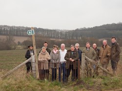
The Berwick A303 Go North Project group invite residents to attend a meeting being held in the Reading Room on Saturday 28 January at 10.00 a.m. At the meeting the Project Group will update and explain key areas as well as providing guidelines with regard to filling in Questionnaires. They will also answer your questions. Questionnaires and booklets will be available for those not yet attending any of the Public Consultations. Or visit:
www.highways.gov.uk/a303stonehenge/consultation
Posted January 20, 2017 11:32 am
Carolyn
Berwick Project Group meeting on Sunday. Update to village next week.
Posted January 19, 2017 1:24 pm
James Hardy
170119 proposed route maps.pdf - Now on website on the following link; http://www.berwickstjames.org.uk/Maps.html
Posted January 19, 2017 7:49 am
Charles Street
I would urge everyone to look at this site http://winterbournestokepc.org.uk/topic/a303-public-consultation/ as it gives us a good idea of what Winterbourne stoke residents are thinking, I suggest it is referred to frequently as it is being added to quite often.
I would refer you to paragraph seven of Olivia Dutton’s comments and to JMD’s comments, the latter being very apt.
Charlie Street
Posted January 18, 2017 6:43 pm
Christian Lange
Hello everybody. This forum has been set up to enable people to comment on the proposals for the A303 Tunnel and Winterbourne Stoke bypass. You do not have to leave you name or your E-mail address. Christian Lange and Carolyn have agreed to take on the moderator function. Please let us know if you spot anything offensive and we will deal with it as soon as possible. Please note that this is a public site and everybody will be able to see your comments. Please note that this is not the place to leave formal feedback. Please leave formal feedback on the following link: https://highwaysengland.citizenspace.com/cip/a303-stonehenge/
James Hardy
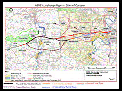
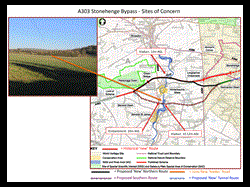
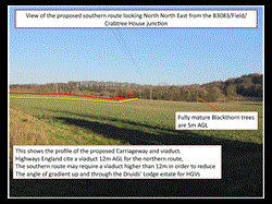
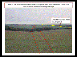
Some of you, like me, may have wrestled a bit with visualising the details of the southern route and thus how to portray it to others.
Attached, some slides that may help; they are in PDF format (for security). I am trying to get them onto the village website but it appears to be a technical step too far for either it or me!
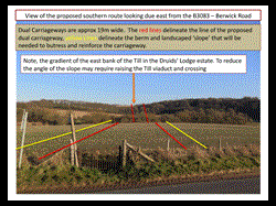
A bit of background, a new dual carriageway is about 19 m wide and has to be supported by a berm and a reinforcing slope that further expand the road’s girth and footprint. This can considerably heighten the road and its silhouette which in our case will make it even more visible - in particular where it goes from being a road to a viaduct to cross the Till and water meadows.
I went into the field next to the village yesterday afternoon - the one that will be bisected by the road - and placed poles at the appropriate distances in the middle of the field in order to show the proposed road footprint, the photos should speak for themselves. I am attempting to meet the Environment Agency to discuss.
Yours,James Hardy
Click on the image to make it larger!
-------------------------------------------------------------------------------------------------------------------------------------------------------------
